NASA-ISRO joint satellite NISAR set for July 30 launch
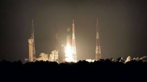
In a remarkable show of global cooperation, NASA and ISRO are preparing to launch one of the most advanced Earth observation satellites to date — the NASA-ISRO Synthetic Aperture Radar, or NISAR. Slated for lift-off on July 30, 2025, from the Satish Dhawan Space Centre in Sriharikota, the mission represents a new frontier in climate monitoring and space collaboration.
A Mission Powered by Partnership
This project reflects the best of U.S.–India space ties. For the first time, the two agencies have come together to develop a satellite with dual-frequency radar technology. NASA contributes the L-band radar, designed to detect ground-level shifts, while ISRO adds the S-band radar, which excels at capturing vegetation and soil data. ISRO is also handling the launch using its GSLV-F16 rocket.
Together, these systems will allow NISAR to track surface changes with high precision. This collaboration isn’t just technical — it’s strategic. It shows how two space agencies can combine strengths for global benefit.
Why NISAR Is a Big Deal
NISAR is built to scan the planet like never before. It will orbit Earth every 12 days, mapping nearly every corner of the globe. Thanks to radar, the satellite can work day or night, in any weather — including heavy cloud cover.
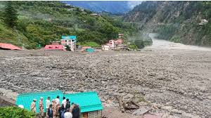
That kind of consistency matters. Earth is changing fast. Scientists need reliable data to monitor key issues like:
- Glacier and ice loss
- Earthquakes and tectonic shifts
- Soil moisture and crop patterns
- Deforestation
- Urban expansion
- Floods, landslides, and coastal erosion
NISAR provides centimeter-level accuracy. This makes it ideal for both short-term emergencies and long-term environmental planning.
What Sets NISAR Apart
The satellite is not only powerful — it’s massive. It weighs around 2,400 kilograms, and its 12-meter radar antenna spans wider than a school bus. Using a technology called SweepSAR, it can capture radar images across a 242 km swath, giving it the reach to cover large areas quickly.
Unlike optical satellites, which need clear skies and daylight, NISAR delivers round-the-clock insights. This makes it especially valuable in areas prone to monsoons, snow cover, or remote locations that are hard to study from the ground.
Best of all, the data from NISAR will be open and free to anyone. From scientists and students to policymakers and humanitarian agencies, anyone with an internet connection will be able to access it.
Strengthening Global Collaboration
Beyond its scientific mission, NISAR signals a deeper diplomatic win. It brings together two major space programs to tackle global challenges like climate change and disaster risk.
NASA and ISRO have collaborated before — such as during India’s Mars Orbiter Mission — but this is their most complex joint effort yet. NISAR strengthens the foundation for future missions, technology sharing, and mutual goals in space exploration.
It also shows the world that science can bridge divides and unite countries in pursuit of knowledge and sustainability.
Countdown to Launch
The launch is scheduled for 5:40 PM IST on July 30, 2025. Once in orbit, NISAR will follow a Sun-synchronous path, staying roughly 743 km above Earth. After launch, the satellite will go through several weeks of testing and calibration before its full-scale data operations begin later in the year.
The mission is expected to last at least three years, though it could operate far longer depending on system performance.
Real-Life Benefits of NISAR
NISAR isn’t just for researchers or climate scientists. Its data has real-world uses that affect daily life. For instance:
- Farmers can monitor crop health and water needs.
- Governments can track illegal deforestation and plan disaster response.
- Cities can monitor land use and infrastructure shifts.
- Rescue agencies can get alerts for floods, landslides, or ground collapse.
Its ability to provide early warnings can save lives, protect property, and reduce economic losses. Over time, NISAR will become a vital tool in managing resources, planning infrastructure, and addressing environmental threats.
The Future Starts Now
The world is at a crossroads. Climate patterns are shifting, extreme weather is rising, and natural resources are under pressure. Missions like NISAR give us the tools to understand, adapt, and respond.
As the launch date nears, the anticipation builds—not just among scientists, but across global communities that rely on environmental stability. NISAR isn’t just a satellite. It’s a step toward a safer, more informed planet.
When it lifts off on July 30, it carries more than sensors and radars — it carries the hope of two nations and the needs of an entire world.