ISRO-NASA NISAR mission: 5 things to know about the costliest Earth observation satellite
In a remarkable partnership, the Indian Space Research Organisation (ISRO) and NASA have joined forces to develop the NISAR (NASA-ISRO Synthetic Aperture Radar) satellite. This mission stands out as the most advanced and expensive Earth observation satellite ever built. It is set to launch from India’s Satish Dhawan Space Centre and promises to deliver unmatched insights about our changing planet. Here are five important things to know about this groundbreaking mission.
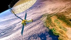
1. Dual Synthetic Aperture Radar Systems: A Technological Breakthrough
What makes NISAR unique is its dual radar system. It carries two synthetic aperture radar (SAR) instruments that work together to observe Earth in detail.
First, NASA developed the L-band radar. This radar uses a wavelength of about 24 centimeters. Because of its longer wavelength, it can penetrate dense vegetation and soil. This capability helps scientists study forests, biomass, and land shifts under thick canopies.
Second, ISRO contributed the S-band radar, which uses a shorter 9-centimeter wavelength. It is designed to monitor ice, snow, and surface changes with fine precision. This radar is excellent for tracking glaciers and frozen surfaces, as well as detecting small surface movements caused by earthquakes or land subsidence.
Together, these radars offer a comprehensive picture of Earth’s surface. They can observe through clouds and darkness, something optical satellites cannot do.
2. Frequent and High-Resolution Earth Monitoring
NISAR will scan all of Earth’s land and ice-covered areas every 12 days. This high revisit rate is essential. It allows scientists to track changes as they happen.
The satellite’s high-resolution radar data will help in many ways. For example, it will improve disaster management by detecting small shifts in the ground before earthquakes or landslides. This early detection can save lives and reduce damage.
Furthermore, NISAR will monitor shrinking glaciers and melting ice sheets. This data is vital for understanding the effects of climate change.
The satellite will also keep an eye on ecosystems. It will track deforestation, wildfires, and other environmental disturbances. Additionally, NISAR’s data will aid agriculture by monitoring crop health and land use changes.
Thanks to its frequent passes and precise instruments, NISAR will become one of the most versatile tools for Earth observation.
3. Scientific and Strategic Importance
NISAR holds great scientific value and strategic significance.
It can support disaster response by providing timely warnings. Detecting small surface changes can alert authorities to upcoming landslides, tsunamis, or earthquakes. This helps protect communities and infrastructure.
Moreover, the satellite will help scientists understand the global carbon cycle by accurately measuring forest biomass. This information is crucial in climate research and policy decisions.
NISAR also aligns with several United Nations Sustainable Development Goals. These include combating climate change, protecting ecosystems, and managing natural resources wisely.
Finally, the mission strengthens scientific cooperation between India and the US. It promotes the exchange of knowledge and advances in Earth sciences.
4. Massive Data Collection and Processing
One impressive aspect of NISAR is its data volume. It is expected to generate more data daily than any previous Earth observation satellite from NASA or ISRO.
To handle this data, NISAR has advanced onboard processing systems. These systems convert raw radar signals into usable data before sending it to Earth. This reduces the bandwidth needed for transmission.
Furthermore, NASA and ISRO plan to make the processed data publicly available. Scientists, policymakers, and the global community will benefit from easy access to this valuable information.
This vast data supply will enable continuous monitoring of Earth’s dynamic systems. It will help researchers answer complex questions about natural and human-induced changes.
5. Exemplary International Collaboration
NISAR is a shining example of successful international teamwork.
NASA is responsible for the L-band radar development. It also provides data processing technology and scientific expertise.
ISRO developed the S-band radar and manages satellite integration. Additionally, ISRO will launch the satellite using its GSLV Mk III rocket, showcasing India’s growing space capabilities.
This partnership reflects decades of trust and cooperation. Both countries share the goal of advancing Earth science and space technology.
Moreover, the success of NISAR will pave the way for future joint missions. It strengthens ties between India and the US while pushing the boundaries of space exploration.
Why Is NISAR So Expensive?
NISAR’s total cost is estimated at about $1.5 billion, making it the most expensive Earth observation satellite ever. Several factors contribute to this price.
First, the integration of two sophisticated radar systems on one satellite is complex and costly. It requires precise engineering and advanced materials to withstand space conditions.
Second, the mission demands cutting-edge onboard data processing technology. Handling the massive data flow adds to development and operational expenses.
Third, the ground infrastructure for receiving, processing, and sharing the data involves significant investment.
Finally, launch services and international collaboration logistics contribute to the overall cost.
Despite the high price, the scientific and societal benefits promise to far outweigh the investment.
What’s Next for NISAR?
NISAR is scheduled to launch on July 30, 2025, from India’s Satish Dhawan Space Centre. It will begin a three-year mission to monitor Earth like never before.
During this time, it will provide detailed, timely data that will help scientists, governments, environmental agencies, and communities worldwide.
By delivering continuous observations with dual radar technology, NISAR will improve our understanding of natural hazards, climate change, and ecosystem dynamics.
In addition, its international collaboration model sets a precedent for future space missions. It shows how scientific innovation can transcend borders for the good of humanity.