Project Elephant review: Census ph-I completed in N-E, over 3,000 km rly lines mapped to prevent collisions
India’s flagship conservation mission, Project Elephant, has achieved a significant milestone. The Phase I elephant census in the Northeast is now complete. At the same time, authorities mapped over 3,000 kilometers of railway tracks that pass through elephant habitats. This step aims to stop deadly train collisions with elephants—one of the top threats to their survival.
Project Elephant Gains Momentum
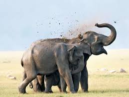
Launched in 1992, Project Elephant helps protect the Asian elephant (Elephas maximus), now classified as Endangered by the IUCN. India shelters more than 60% of the global population of these elephants. That makes its conservation efforts vital to the species’ future.
The project focuses on protecting elephants and their habitats, managing human-elephant conflict, and securing migratory corridors. Over the years, the mission has evolved. It now uses technology, community partnerships, and better field data to boost its impact.
Northeast Leads in Phase I Census
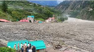
Phase I of the 2025 Elephant Census focused on the seven northeastern states—Assam, Arunachal Pradesh, Meghalaya, Mizoram, Tripura, Nagaland, and Manipur. These areas are rich in forests and hold key migratory routes that link India with Bhutan and Myanmar.
Forest departments worked with researchers, NGOs, and volunteers. They used scientific methods like:
- Block sampling
- Dung density analysis
- Camera traps
- Drone surveillance
This census also used mobile data apps and GIS tools to make the process faster and more transparent. Early observations suggest that elephant numbers in the Northeast remain stable. Final figures will come after Phase II ends later this year.
Over 3,000 km of Railway Tracks Mapped
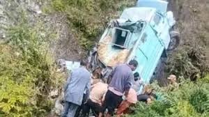
Train accidents continue to kill many elephants, especially in regions like North Bengal and Assam. To address this, the Ministry of Environment and the Ministry of Railways teamed up. Together, they mapped more than 3,000 km of railway lines that cross elephant zones.
This mapping effort helps in several ways:
- It spots collision-prone zones.
- It sets up speed limits for trains in high-risk areas.
- It supports early warning systems using sensors and thermal cameras.
- It guides the construction of underpasses and overpasses.
- It connects forest guards with train operators via mobile alerts.
Forest officials and railway pilots now share real-time alerts about elephant movements. This helps trains slow down or stop before an accident can happen. In some pilot areas, early warning systems have already started working.
Human-Elephant Conflict Still Rising
While tech solutions are growing, human-elephant conflict (HEC) is getting worse in many states. As forests shrink, elephants enter farms and villages, often in search of food and water.
States like Chhattisgarh, Kerala, Karnataka, and Jharkhand see frequent reports of crop loss, damaged houses, and even deaths. Local communities bear the burden.
To reduce conflict, state governments are adopting measures like:
- Solar fencing to protect crops.
- Compensation schemes for losses.
- Elephant-friendly farming practices.
- Community awareness drives.
Eco-development committees now work closely with local villagers. These groups help reduce fear and hostility by involving people in conservation.
Plans for New Elephant Reserves
To support elephant movement and protection, the government may approve two new Elephant Reserves—one in Madhya Pradesh and another in Telangana. If approved, this will raise the total to 35 reserves across 15 states.
These reserves offer secure space for elephants to live and migrate. They also protect other species and help restore India’s rich biodiversity.
Tech Boosts Conservation
One major change in the new phase of Project Elephant is the use of advanced technology. The Elephant Corridor Mapping System (ECMS), for example, uses GIS tools to spot blocked or fragmented corridors. Officials can then plan ways to reconnect them.
Another project, AI for Elephants (AIfE), uses artificial intelligence to track elephant movements. It also predicts conflict zones and gives real-time suggestions to forest officers.
These tools help move from reactive to preventive conservation—saving both elephants and human lives.
Next Phase: Southern and Central India
The second phase of the census will begin in July 2025. It will cover southern and central states like Karnataka, Tamil Nadu, Odisha, Andhra Pradesh, and Chhattisgarh. These regions hold a large part of India’s elephant population.
This phase will follow the same scientific process as the Northeast. It will also use mobile and satellite tools to ensure faster, more accurate results.
The final report of the national elephant census will likely be published by early 2026. Experts believe it will give India’s most complete picture of its elephant population yet.
Why This Matters
The combination of updated population data and mapped railway lines offers a fresh chance to protect elephants. By using science, local knowledge, and policy, India hopes to balance conservation with development.
Union Environment Minister Bhupender Yadav recently said, “Elephants are a symbol of our cultural and ecological heritage. We must ensure their safety in the wild.”
This renewed momentum under Project Elephant shows that India is serious about securing its wildlife—before it’s too late.